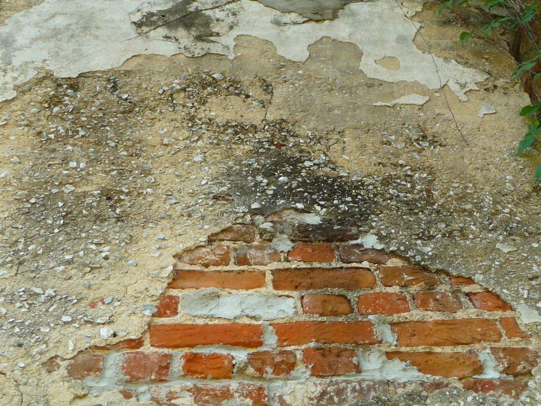
Tabby Ruins Travel Guide
Barbara Stevenson
  • Home
  • List
  • Blog
  • Contact

Tabby Horn Work Remnant

10/23/2017

2 Comments

 
Description

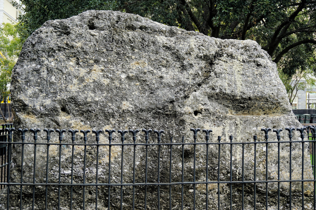
A lone tabby slab stands in Charleston’s busy Marion Square, a small remnant of what was once a massive fortification. It is surrounded by a fence with a plaque that reads, “Remnant of Horn Work. May 1780. Siege of Charleston.”

History

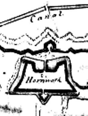
In 1757 construction began on a large earth and tabby horn work, which is a fortified wall with two half-bastions (the “horns”). It served as town gate near today’s King Street and included a gate and drawbridge. Fortifications were deemed necessary to protect Charleston against the Spanish. However, as the conflict with Spain came to an end—as did the subsequent war with England, the city decided it no longer needed the fortifications. The horn work was destroyed in 1784. (The map and information on the horn work comes from Nic Butler’s blog, the Mayor’s Walled City Task Force.)

Location

GPS: N 32°47.206 and W 79°56.181

Address: Marion Square (by the side of King Street across from the Marion Francis Hotel), Charleston SC 29403
​
Accessibility: always open to the public

2 Comments

Riverside Plantation Tabby Ruin

9/28/2015

0 Comments

 
Picture
Riverside Plantation (Photo by Barbara Stevenson)
Description

A remnant of a tabby outbuilding that was part of Riverside Plantation sits on Landsend Woodland property on St. Helena Island, SC. The standing wall has two windows.

History

Riverside Plantation belonged to Daniel Jenkins, who married Isabella Field in 1805. Isabella inherited the plantation after her husband’s death, and through her four marriages, she acquired five plantations. In the 1920s Gullah natives of St. Helena purchased the property and formed the Landsend Woodland Club. Riverside Plantation was placed on the National Register of Historic Places in 1988 (see South Carolina Department of Archives and History).

Location

GPS: N 32°18.982 and S 80°38.623

Address: Lands End Woodland Beach, St. Helena Island, SC 29920. Lands End Woodland is an unpaved road that extends from Lands End Road to the shoreline.

Accessibility: Landsend Woodland is private property that is occasionally open to the public, most notably during the annual Lands End Woodland River Festival. For more information, see Landsend Woodland.

0 Comments

Bleak Hall Plantation Tabby Ruins

9/12/2015

2 Comments

 
Bleak Hall Plantation Ice House (Photo by Barbara Stevenson)
Bleak Hall Plantation Gardener Shed (Photo by Barbara Stevenson)
Bleak Hall Plantation Barn (Photo by Barbara Stevenson)
Description

The tabby ruins of Bleak Hall Plantation are part of the Botany Bay Plantation Heritage Preserve and Wildlife Management Area located on Edisto Island, SC. There are three Gothic Revival architectural ruins: a white wooden ice house constructed on tabby foundations, a tabby gardener shed, and a tabby barn.

History

The plantation property belonged to the Townsend family from 1798-1933 and was named after Charles Dickens’ novel, Bleak House. After the Civil War, a fire destroyed much of the plantation, but the three tabby outbuildings survived. Constructed in the 1840s, they feature characteristics of Gothic Revival architecture, including spires, gable roofs, dentil molding, and mock arched doors and windows (although a fire in the 1970s destroyed much of the ornamentation of the barn). The property was eventually acquired by John Meyer, who deeded it to the state. Consequently, the South Carolina Department of Natural Resources opened Botany Bay Plantation to the public in 2008. In addition to Bleak Hall, the brick ruins of Sea Cloud Plantation and other historic structures are on the preserve, which consists of pine-hardwood forests, agricultural fields, coastal wetlands, and a boneyard beach.

Location

GPS: N 32°33.513 and W 80°15.276

Address: 1066 Botany Bay Rd., Edisto Island, SC 29438 (Botany Bay Rd. is an unpaved road that permits cars to drive through the preserve. Maps are available at the entrance.)

Accessibility: Free and open to the public, except closed on Tuesdays and for scheduled hunts. For more information, visit http://www.sciway.net/sc-photos/charleston-county/botany-bay.html.

2 Comments

Sams Plantation Complex Tabby Ruins

6/8/2015

1 Comment

 
Sams Plantation Complex (Photo by Bill Hill)
Sams Plantation Dairy and Cold Room (Photo by Bill Hill)
Sams Plantation Kitchen (Photo by Bill Hill)
New Tabby Discovery (Photo by William A. Riski)
Description

Sams Plantation on Dataw Island, SC, is an extensive complex of tabby ruins including the sprawling plantation house, kitchen chimney, dairy/cold room, barn/stable, blade house, slave quarters, chapel, and cemetery.

History

William Sams purchased Dataw Island in 1783 and began construction of a tabby plantation devoted to sea island cotton. His son, B. B. Sams, inherited the plantation in 1808 and expanded it to include approximately 15 tabby buildings. Not only was this a large plantation that included its own chapel and cemetery, but it was also unusual in that nearly all the structures were built of tabby. Sams died in 1855, and the federal government took over the island in 1863 because of overdue taxes. A fire destroyed the plantation in 1876. In 1983 Alcoa began construction of a residential community on the island. Alcoa and island residents formed the Dataw Historic Foundation committed to the preservation of the Sams Plantation Complex Tabby Ruins.

Update: William A. Riski of Dataw Island reports that an excavation conducted in March 2018 next to the chimney has unearthed tabby dating from the 1700s. Studies are underway to determine the function of these early tabby remnants. 

Location

GPS: N 32°25.927 and W 80°34.991

Address: 100 Dataw Club Rd., Dataw Island, SC 29920 (The ruins are in the vicinity of the clubhouse, golf course, and tennis courts.)

Accessibility: Dataw Island is a private gated community. (We had reservations at a restaurant on the island, so the guard checked us in and allowed us on the island.)

For more information, see the Dataw Historic Foundation.

1 Comment

Old Sheldon Church Ruins

4/27/2015

0 Comments

 
Old Sheldon Church (Photo by Cheryl Warren)
Old Sheldon Church Tabby (Photo by Cheryl Warren)
Description

Old Sheldon Church ruins feature majestic brick columns, but tabby is minimal. Tabby can be detected as a mortar and as sparsely remaining stucco. A graveyard is adjacent to the church. The scenic spot is popular for weddings and is under the auspices of the Parish Church of St. Helena.

History

According to signs at the site, Old Sheldon Church--originally named Prince William's Parish Church--was erected in 1751 and was burned by Loyalists in 1779. It was rebuilt in 1825, but freedmen dismantled it shortly after the Civil War.

Location

GPS: N 32°37.113 and W 80°46.837

Address: Old Sheldon Church Road, Yemassee, SC 29945

Accessibility: Located about 17 miles north of Beaufort, on Old Sheldon Church Road between
Highways 17 and 21. A parking lot is across the road from the ruins.

0 Comments
<<Previous

    Archives

    October 2017
    August 2017
    December 2016
    September 2016
    August 2016
    July 2016
    May 2016
    April 2016
    March 2016
    February 2016
    January 2016
    December 2015
    November 2015
    October 2015
    September 2015
    June 2015
    May 2015
    April 2015

    ©Barbara Stevenson
    

    This  site is the property of Barbara Stevenson. Unless otherwise noted, any borrowed content must give credit to:
     www.tabbyruins.com.

    RSS Feed

    Categories

    All
    Florida
    Georgia
    South Carolina

Powered by Create your own unique website with customizable templates.