Tabby Ruins Travel Guide
Barbara Stevenson
  • Home
  • List
  • Blog
  • Contact

Sister's Creek Tabby House Walls

9/22/2016

6 Comments

 
Description

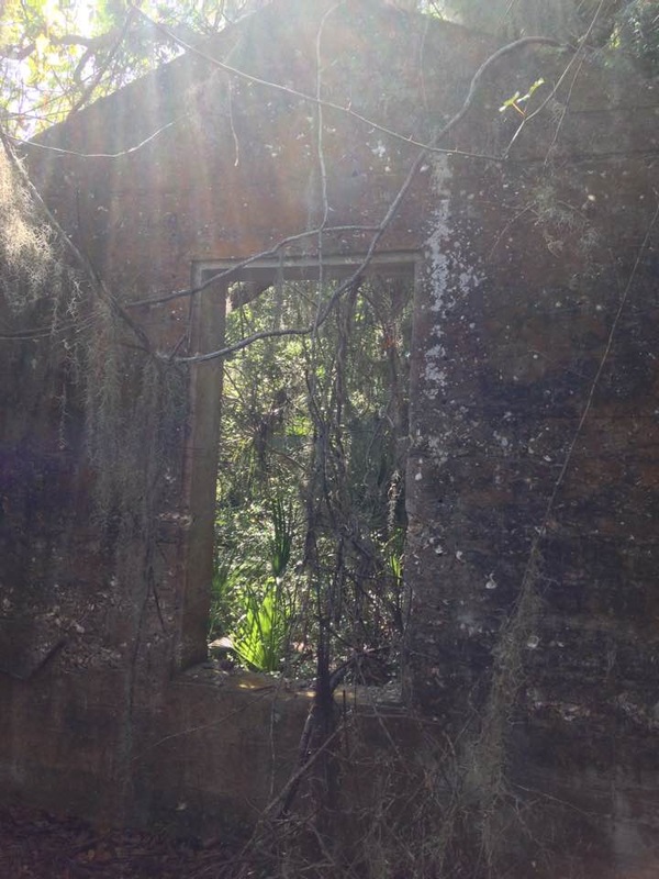
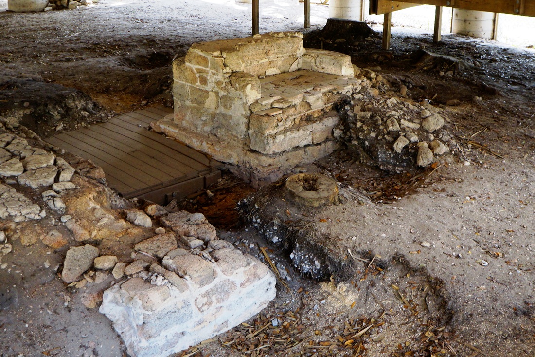
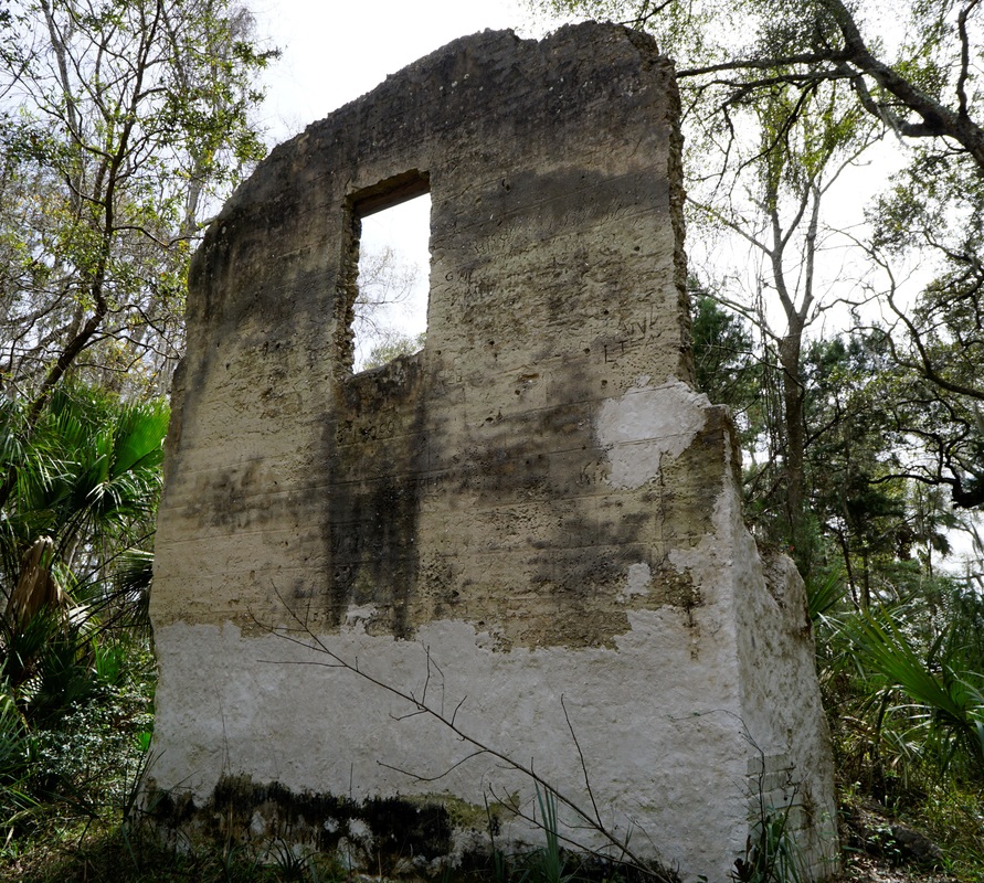
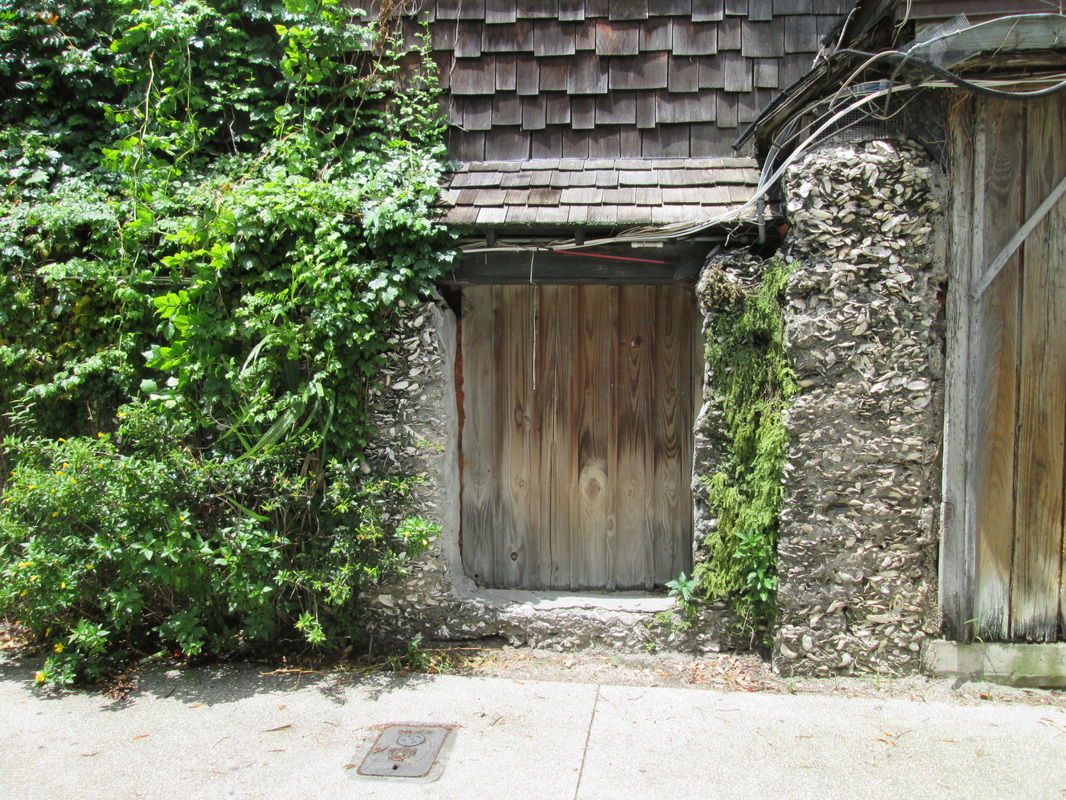
This entry on the recent discovery of tabby house walls at Sister’s Creek in Jacksonville FL is courtesy of J. Scott Barnard, a graduate student at the University of North Florida. Scott reports the house was uncovered while the woods were being cleared for construction of the new Sister’s Creek bridge on Heckscher Drive. The house’s walls are still standing, but a brick fireplace has been removed. Its history is unknown, but Scott thinks it might have been a one-room slave cabin dating from the 19th century.

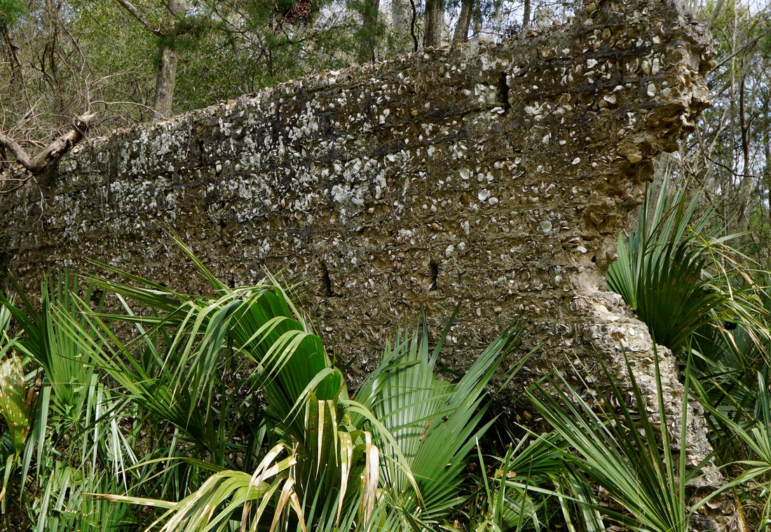
It is on protected archaeological land near shell middens. Extensive middens in the area provided the oyster shells for this house, the Kingsley Plantation slave cabins, the Thomson House, and the Fitzpatrick Plantation walls—tabby sites all located within a 20-mile radius of each other in the vicinity of the Timucuan Preserve.

Location

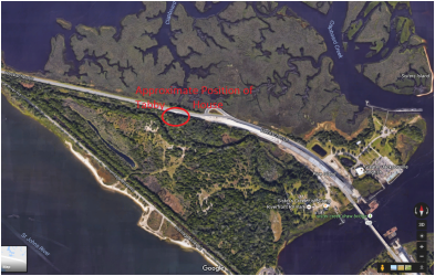
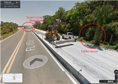
Visitors headed to Kingsley Plantation can catch a glimpse of the tabby walls in the woods off to the side of Heckscher Drive in Jacksonville FL. The site is west of the new Sister’s Creek bridge on the south side of Heckscher. There is no parking lot, and no information is available on the stability of the walls.
​
Scott has kindly provided the following images to indicate location:

Picture
Picture
6 Comments

Mala Compra Plantation Archaeological Site

7/19/2016

2 Comments

 
Picture
Mala Compra Plantation (Photo by Barbara Stevenson)
Description

A boardwalk for visitors surrounds this covered archaeological site with coquina and tabby remnants from a plantation in Palm Coast FL.

History

Joseph Hernandez, Florida's first delegate to the U.S. Congress in 1822 and the nation's first Hispanic congressman, purchased Mala Compra (Spanish for "bad bargain") in 1816. The cotton plantation was destroyed during the Florida War (1835-43) between Seminoles and whites.

The archaeological site was created in 1999. Excavations revealed the foundations of the main house, a kitchen/wash house, and coquina well. The main house was built with tabby floors and a wood frame supported by coquina blocks. Whereas tabby is an oyster shell concrete, coquina is a shellstone found along the coast of Northeast Florida.

​Location

GPS: N 29°36.963 and W 81°12.251

Address: 5862 N. Oceanshore Blvd., Palm Coast FL 32137 (in Bing's Landing Park off State Road A1A)

Accessibility: Free and open to the public at any time
2 Comments

Fitzpatrick Plantation

4/4/2016

14 Comments

 
Description

Two tabby walls face each other in the isolated woods of Cedar Point, located at the southern end of Black Hammock Island in the Timucuan Preserve National Park in Jacksonville, FL. 

History

The tabby ruins are believed to be the remnants of the plantation established by William Fitzpatrick in 1795 on Cedar Point. In 1848 the land was sold to the Broward family, and in the 1990s it became part of the Timucuan Preserve National Park, which also includes the Thomson House and Kingsley Plantation tabby structures. (For more information see http://www.blackhammockisland.com.)

Location

Fitzpatrick Plantation proved difficult to find because the park and its website do not provide any information on the ruins. A sign at the site warns visitors away because the walls have not been stabilized, and so this may explain why no information is available. Below are details on driving to Cedar Point and walking to the ruins:

GPS: N 30°26.633 and W 81°27.700 (Cedar Point Boat Ramp Parking Lot)
          N 30°26.524 and W 81°27.931 (ruins)

Address: The Cedar Point Boat Ramp parking lot is located at ​9023 Cedar Point Road, Jacksonville FL 32218. Directions are given on the Timucuan Preserve website, and the location appears on the map below. At one point the road makes a sharp turn, and failing to make the turn will put the driver on a different road.

Visitors can find the start of a path at a sign at the boat ramp. Or, instead of parking at the boat ramp, visitors can follow Cedar Point Road to its very end and find the path located behind the gate, which appears to be the shorter route to the hiking trail.
 
Both paths converge at a sign outlining the Cedar Point hiking trails. The quickest way to the ruins is to follow the blue route (not the red) and keep left each time it forks. It is about .8 of a mile to the ruins.

Accessibility: Visitors need to be physically able to walk about two miles. Since the ruins are in a maritime forest, it is advisable to wear bug spray to ward off mosquitoes and ticks, and to wear covered shoes in case snakes or other creatures are encountered. Winter is the best time to visit.


14 Comments

Thomson Tabby House

3/18/2016

2 Comments

 
 Description

Visitors to Kingsley Plantation in Jacksonville FL will see on Fort George Road the unfinished Thomson tabby house, which sits atop the McGundo Midden.

History

It is believed that the house was being constructed in 1854 by Charles Thomson, owner of Fort George Island. However, construction was halted when he died in 1855.

Many planters owned Fort George Island, most famously Zephaniah Kingsley, who built Kingsley Plantation and its tabby slave cabins during 1814-1837. The State of Florida created Fort George Island Cultural State Park in the 1950s, and the island became part of the Timucuan Preserve National Park in the 1990s.

The McGundo Midden can be seen in the woods adjacent to the Thomson tabby house. The piles of oyster shells in the midden would have been used in making the tabby, as was common practice. (For more information visit the Timucuan Preserve website and the Fort George Island Cultural State Park Unit Management Plan.)

Location

GPS: N 30°24.562 and W 81° 25.864

Address: ​Fort George Rd., Jacksonville FL 32226 (The house is on the side of the road just before the intersection with Palmetto Avenue.)

Accessibility: The house sits on the side of the road and is accessible any time.

2 Comments

St. Augustine--The First Tabby

4/13/2015

3 Comments

 
St. Augustine is the original home of tabby in America. The Spanish arrived in St. Augustine in 1565, and the first documented reference to tabby occurred in 1580. In fact, the word “tabby” may derive from the Spanish word tapia, meaning “mud wall.” Also in 1580, the Spanish discovered coquina, a natural shellstone that could be quarried, so the oldest surviving buildings of Spanish rule are a combination of coquina and tabby. The British takeover of the city in 1764 ushered in the destruction of most tabby buildings, so there are few remnants today. (For more information on the history of St. Augustine tabby, see Janet H. Gritzner’s article, “Distributions of Tabby in the Southern United States,” in The Conservation and Preservation of Tabby.) 

The sites listed below illustrate the history of tabby and the Spanish colony in St. Augustine:

Mission de Nombre de Dios

It is here on Mission Grounds in 1565 that Pedro Menéndez de Avilés landed and began the Spanish colony in Florida. A marker in the historic park indicates the location of the oldest known tabby and coquina—the foundations of a church and friary dating from 1677. Unfortunately, archaeologists have covered the ruins, so only the marker is visible. 
Mission Grounds (Photo by Barbara Stevenson)
Marker for Coquina and Tabby Church (Photo by Barbara Stevenson)
GPS: N 29°54.302 and W 81°19.007 (parking lot) 

Address: 27 Ocean Avenue, St. Augustine, FL  32084

Accessibility: The mission is open to the public and consists of a museum, church, chapel, and historic park (although the archaeological excavation is covered and unavailable for public viewing). For more information, visit the website of the Mission de Nombre de Dios.

Castillo de San Marcos

Constructed 1672-1695, the massive Castillo de San Marcos is the oldest standing fort in the United States. It was built primarily with coquina, but some tabby was used. (However, it seems to me that in St. Augustine the floors identified as tabby have much smaller and fewer shells than tabby elsewhere.)

Coquina Walls of Castillo de San Marcos (Photo by Barbara Stevenson)
Tabby Floor (Photo by Barbara Stevenson)
Location 

GPS: N 29°53.798 and W 81°18.676

Address:  1 S. Castillo Drive, St. Augustine, FL 32084

Accessibility: There is a parking lot in front of the fort and at the nearby Visitor Center. Open every day, except Christmas, from 8:45am-4:45pm. Admission is $7 for those over the age of 15. For more information see the website for the Castillo de San Marcos National Monument.

St. George Street Tabby Walls

St. George Street is a popular pedestrian walkway with stores and restaurants in the heart of the historic district. Most of the tabby walls along historic St. George Street are stuccoed, but exposed tabby can be seen in a couple of spots. 
St. George Street Tabby Wall (Photo by Barbara Stevenson)
St. George Street Tabby (Photo by Barbara Stevenson)
Location 

One wall is by the Oldest Wooden Schoolhouse in the U.S. at 14 St. George Street and Tolomato Lane
(GPS Coordinates N 29°53.847 and W 81°18.818).

Another is by Mill Top Tavern at 19 St. George Street
(GPS Coordinates N29°52.824, W81°18.809). 

Accessibility 

Park at the nearby Visitor Center, which is also close to the Castillo San Marcos. The Visitor Center is located off I-95 at 10 W. Castillo Dr, St Augustine, FL 32084. For more information, see http://www.staugustinegovernment.com/sites/vicparking/index.cfm. 
3 Comments
<<Previous

    Archives

    October 2017
    August 2017
    December 2016
    September 2016
    August 2016
    July 2016
    May 2016
    April 2016
    March 2016
    February 2016
    January 2016
    December 2015
    November 2015
    October 2015
    September 2015
    June 2015
    May 2015
    April 2015

    ©Barbara Stevenson
    

    This  site is the property of Barbara Stevenson. Unless otherwise noted, any borrowed content must give credit to:
     www.tabbyruins.com.

    RSS Feed

    Categories

    All
    Florida
    Georgia
    South Carolina

Powered by Create your own unique website with customizable templates.