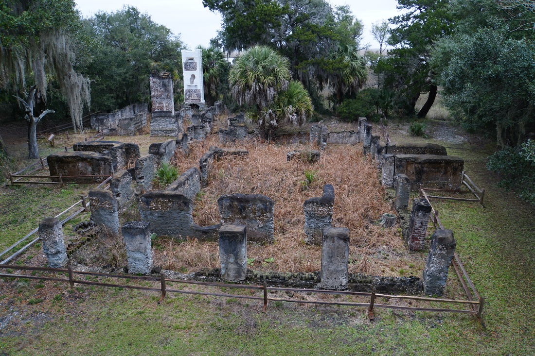
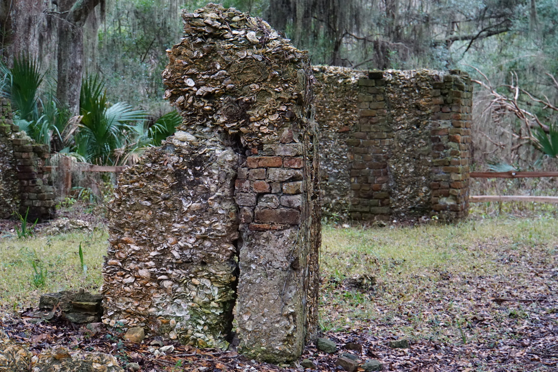
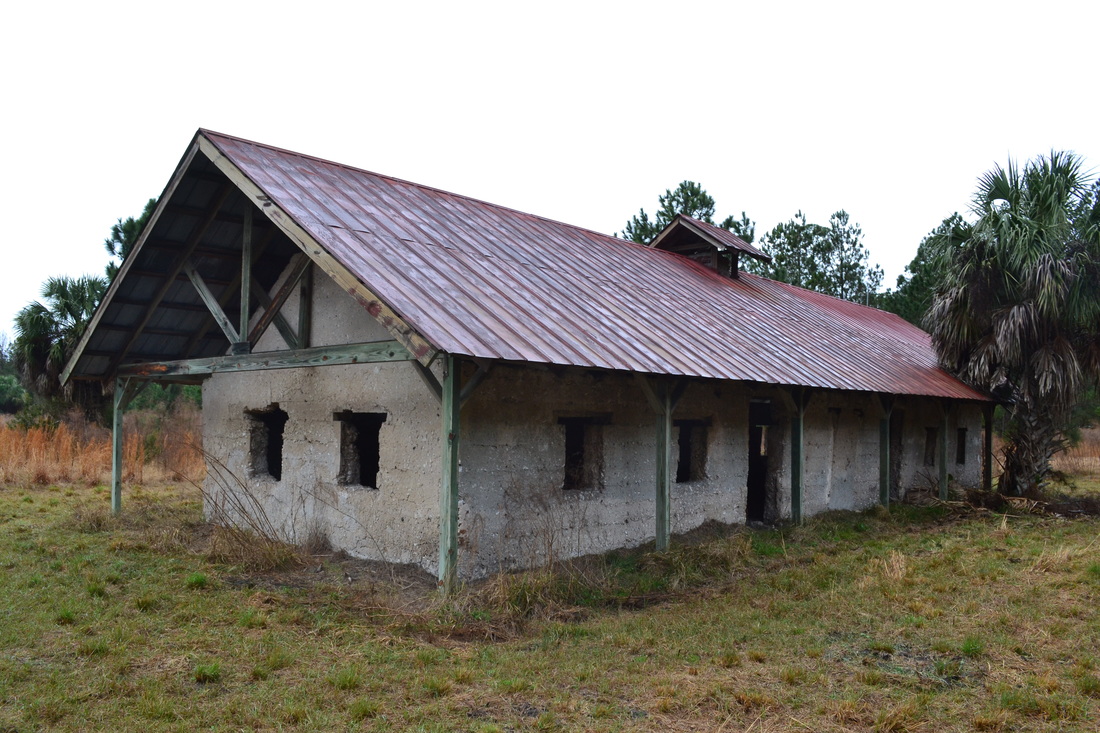
Tabby Ruins Travel Guide
Barbara Stevenson
  • Home
  • List
  • Blog
  • Contact

Cannon's Point

1/30/2016

5 Comments

 
Description

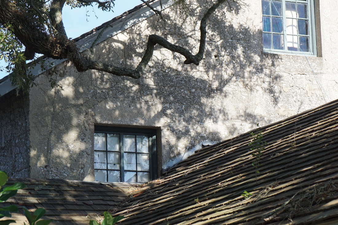
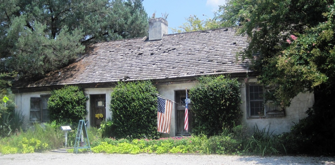
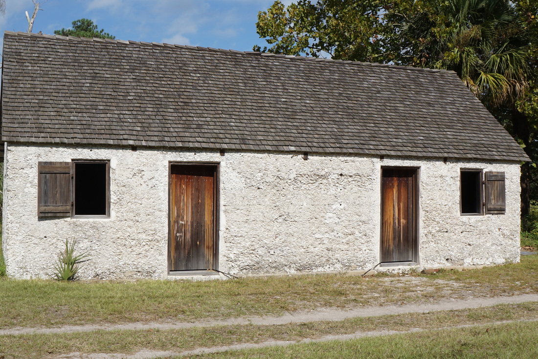
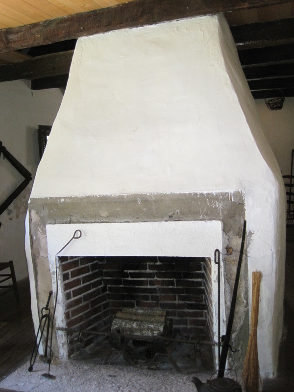
Cannon's Point Preserve on St. Simons Island contains the scattered ruins of John Couper's plantation. The ruins consist of a tabby potato barn, slave cabin rubble, the brick chimney of the overseer's house, and the plantation complex that includes a detached kitchen and what is probably the remnants of a hospital. The plantation complex was built with tabby taken from Fort Frederica, poured tabby, and bricks.

History

Cannon's Point was home to Native Americans, as demonstrated by shell middens dating back to 2500 BCE. Daniel Cannon, James Oglethorpe's carpenter, was allowed to settle there. John Couper purchased the property in 1793 and built a thriving plantation. Couper died in 1850, and after the Civil War, the property changed ownership several times. In 2012 St. Simons Land Trust purchased the property and set up Cannon's Point Preserve. (For more information go to http://www.sslt.org/pro_cpp_visit.php).

Location

GPS: N 31°15.614 and W 81°20.488 (Parking lot)

Address: Cannon Point Road, St. Simons Island GA 31522. (Go north on Frederica Road. At the traffic circle on the north end of the island, take Lawrence Rd. Travel about 3 miles and there will be a sign for Cannon’s Point Preserve on the right side of the road. Follow the directions to the parking lot.)

Accessibility: Free and open to the public 9 am to 3 pm, Saturday through Monday. Volunteers are available to orient visitors and offer assistance. No cars allowed, no restrooms or other facilities available. Maps are stored at the kiosk at the entrance.  It is a 5-mile hike or bike ride to visit the ruins and return to the parking lot. Each winter several van tours through the preserve are offered by the Coastal Georgia Historical Society (visit http://www.saintsimonslighthouse.org/index.html.)

5 Comments

St. Catherines Island Tabby Structures

12/16/2015

4 Comments

 
Picture
Tabby Church Building (Photo from St. Catherines Island Foundation)
Description

Antebellum tabby buildings are used by researchers on St. Catherines Island, which is closed to the general public. A tabby slave cabin serves as a guest house, and a tabby barn holds equipment. Another tabby building was once a church for freed slaves.

History

St. Catherines, located off the coast of Georgia, was an important center for the Guale Indians. Spanish missionaries converted natives on the island and constructed the Mission Santa Catalina de Guale in the late 1500s. The mission was abandoned in the late 1600s after the arrival of the British, and this site of North America's oldest Catholic Church disappeared until archaeologists from the American Museum of Natural History found it in the late 1970s.

The island became part of the Georgia colony and was given to Mary Musgrove, the Indian princess who served as translator for the English. Musgrove and her husband Thomas Bosomworth established a plantation once slavery became legal in Georgia in 1749. After her death, the island was sold to Button Gwinnett, signer of the Declaration of Independence, and the Antebellum structures on the north end of the island (the location of today's compound for researchers) are believed to date from his time. The Waldburg family came to own the entire island until the Civil War. 

For a brief time after the Civil War, St. Catherines came under the control of the Freedman's Bureau and was run by Tunis Campbell, until the federal government forced the ex-slaves to leave. The former slaves turned a tabby building on the south end of the island into a church. The island had various owners until 1943 when Edward Noble purchased it. The Noble family has turned the island over to the St. Catherines Island Foundation, which today supervises research programs on the island. For more information, visit St. Catherines Island Foundation website.

Location

GPS: N 31°40.143, W 81°09.492 (St. Catherines Dock and Compound, on the north end of the island)

Address: The island can only be reached by boat. Boats typically depart from Halfmoon Marina, located at 171 Azalea Rd., Midway GA 31320.

Accessibility: ​Closed to the public
4 Comments

Retreat Plantation Tabby

11/17/2015

18 Comments

 
Retreat Plantation Slave Hospital (Photo by Barbara Stevenson)
Retreat Plantation Greenhouse (Photo by Barbara Stevenson)
Retreat Plantation Corn Barn (Photo by Barbara Stevenson)
Tabby House Gift Shop (Photo by Barbara Stevenson)
Description

Sea Island Golf Club on St. Simons Island maintains several remnants from Retreat Plantation: the tabby ruins of a slave hospital, tabby walls from a green house, a tabby corn barn converted into a golf course clubhouse, the brick ruins of the plantation house, and a slave cemetery. One remaining tabby slave cabin, located on Frederica Rd., has been restored and turned into a gift shop.

History

The first plantation on the southwestern portion of St. Simons Island was Orange Grove, constructed by Thomas Spalding in the 1790s. In 1804 Major William Page purchased it and created Retreat Plantation. After his death in 1827, it passed to his daughter Anna and her husband, Thomas Butler King. During the Civil War, the slave Neptune Small retrieved the body of his master, Henry Lord King, from the battlefield at Fredericksburg and brought him home for burial. To reward his loyalty, the King family gave Neptune a parcel of land after the war (now Neptune Park by the ocean pier) and after his death erected a tombstone in his honor in the Retreat Plantation cemetery. Developer Howard Coffin bought Retreat Plantation in the 1920s and converted it to a golf club.

Location

GPS: N 31°08.405, W 81°24.418 (ruins at Sea Island Golf Club)
Address: 100 Retreat Ave., St. Simons Island GA 31522. Just a short walk from the golf course parking lot, the ruins are situated between Plantation Golf Course and the driving range.
Accessibility: Only guests of Sea Island are allowed on the property.

GPS: N 31°09.533, W 81°23.325 (Tabby House Gift Shop)
Address: 1550 Frederica Rd., St. Simons Island GA 31522 (at the Demere Rd. traffic circle)


​
18 Comments

Ossabaw Island Tabby Buildings

10/27/2015

1 Comment

 
Ossabaw Island Slave Cabin (Photo by Barbara Stevenson)
Ossabaw Island Tabby Smokehouse (Photo by Barbara Stevenson)
Description

A tabby smokehouse and three tabby slave cabins stand on the northern end of Ossabaw, an island just south of Savannah accessible only by boat.

History

Once the English acquired the island, merchant John Morel purchased it in 1760. He and his descendants constructed a slave plantation on the northern portion of the island where the tabby outbuildings are located. They were erected in the 1820s. The rest of the island was sold to three other slave owners.

After the Civil War, freedmen lived on the island until hurricanes forced them to relocate to the mainland community of Pin Point in 1898. In 1924 Henry and Nell Torrey bought the island and built a Mediterranean stucco mansion on the North End. Their daughter Eleanor and her husband Clifford West established the Ossabaw Project in 1961, inviting artists and researchers to work on the island. In 1978 Mrs. West arranged to sell the island to Georgia to create the state's first heritage preserve. 

Location

GPS: N 31°50.309 and W 81°05.544 (tabby outbuildings)

Address: The ferry boat for Ossabaw's North End leaves from Delegal Creek Marina located at 1 Marina Dr., Savannah GA 31411 (in the Landings gated community on Skidaway Island). On Ossabaw an unpaved road goes from the dock through the island. The first building along this road is the Clubhouse. A footpath leads from the Clubhouse to the tabby buildings.

Accessibility: The island is open to visitors several times a year. To learn more about Ossabaw and opportunities to visit the island, see Ossabaw Island Foundation and Ossabaw Island Home.


1 Comment

Hamilton Plantation Slave Cabins

6/27/2015

1 Comment

 
Hamilton Plantation Slave Cabin (Photo by Bill Hill)
Hamilton Plantation Slave Cabin (Photo by Barbara Stevenson)
Description

Three restored slave cabins remain from Hamilton Plantation on St. Simons Island. The Cassina Garden Club restored two of the cabins with stucco walls and with authentic artifacts to illustrate the lives of slaves. Each cabin has a fireplace in the center, which acted as a divider to create two rooms for two families.

History

Hamilton Plantation, started around 1793 by James Hamilton, was located on Gascoigne Bluff, overlooking Frederica River and the site of Georgia’s first naval base. The plantation burned in 1890 and was replaced by a lumber mill. By 1950 the Methodist Church had purchased much of the land for their retreat, Epworth By the Sea (including one of the cabins), and the Cassina Garden Club became stewards for the other two cabins. 

Location 

GPS: N 31°10.238 and W 81°24.430

Address: 1000 Arthur J. Moore Drive, St. Simons Island, GA 31522 

Accessibility: Operated by the Cassina Garden Club, the two cabins are open to the public during June-August on Wednesday mornings from 10:00am to noon, during the club’s special events, and by request from groups visiting the island (see the club’s website at www.cassinagardenclub.org).

1 Comment
<<Previous
Forward>>

    Archives

    October 2017
    August 2017
    December 2016
    September 2016
    August 2016
    July 2016
    May 2016
    April 2016
    March 2016
    February 2016
    January 2016
    December 2015
    November 2015
    October 2015
    September 2015
    June 2015
    May 2015
    April 2015

    ©Barbara Stevenson
    

    This  site is the property of Barbara Stevenson. Unless otherwise noted, any borrowed content must give credit to:
     www.tabbyruins.com.

    RSS Feed

    Categories

    All
    Florida
    Georgia
    South Carolina

Powered by Create your own unique website with customizable templates.